Best Austin Skyline Drone Spots
Austin's skyline is a mix of shimmering glass and lakeside greenspace—perfect for clean horizons, reflections, and leading lines. Below is a practical, field-ready guide to the most reliable launch areas and vantage points, plus light, framing, and quick rule reminders so you come home with keepers (not warnings).
How to Use this Guide (and fly smart)
- Stay under 400 ft AGL, maintain VLOS, and never fly over people who aren't part of your operation.
- Check for Temporary Flight Restrictions (TFRs) before each flight (big events can pop TFRs downtown).
- Some City of Austin parks/venues require permission to launch/land. If in doubt, use nearby public right-of-way with clear takeoff/landing space and avoid crowds.
- Recreational? Complete TRUST and register drones >0.55 lb. Commercial? Part 107 applies.
- Bring ND filters, charged batteries, and a spotter for busy riverfront areas.
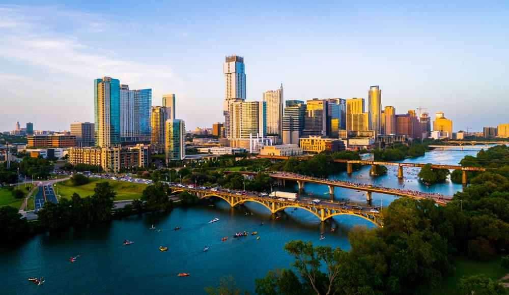
Congress Avenue Bridge: The Iconic Axis
Set up along the north bank and let Congress Avenue lead the eye straight through downtown. A low approach over the water gives you clean reflections; a slow rise stacks The Austonian and neighbors into a crisp, layered silhouette. Aim for golden hour or the first moments of blue hour when façades glow and the lake turns mirror-calm.
Vic Mathias Shores (Auditorium Shores): Wide, Balanced Cityscapes
From the south shore lawns, the skyline spreads evenly across your frame with bridges adding subtle geometry. Keep your motion unhurried—gentle push-ins and side tracks read beautifully here—and allow twilight to switch the scene from warm daylight to cool city sparkle. On event days, choose a quieter corner and maintain generous standoff from footpaths.
Lou Neff Point: Morning Reflections with Natural Lead-Ins
At the bend where the river curves toward town, sunrise paints the towers while the water settles into glass. Fly low and long, letting the S-curve act as a natural leading line into downtown. Even modest altitude delivers depth: foreground water, mid-ground trees, and a crisp skyline anchor.
Seaholm & Shoal Creek: Texture Meets Glass
The Seaholm Power Plant and the mouth of Shoal Creek add industrial texture against sleek high-rises. Work a diagonal that places the Seaholm stack on one third and downtown on the other, then let side-light carve detail into concrete and steel. It's a great spot for a subtle orbit that reveals contrast without crowding the creek trail.
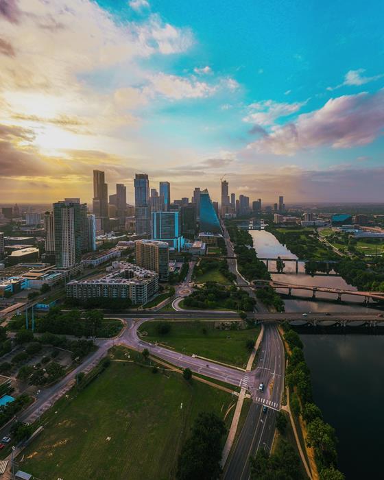
Long Center & Doug Sahm Hill: Reveals and Symmetry
From the Long Center terrace and the nearby hill, you can stage elegant reveals—lift slowly from the knoll and introduce the skyline as the horizon expands. Paths and railings create gentle geometry you can echo in your framing. Blue hour is especially kind here: balanced ambient light, legible foregrounds, and a skyline that reads cleanly.
Holly Shores / Festival Beach: East-Side Sunrise and Night Glow
Looking west from the Holly Shores area, the skyline silhouettes against a rising sun for graphic, high-contrast frames. Return after dusk to the Festival Beach boat area for night reflections that spread softly across the lake. Keep your altitude modest and let water do the heavy visual lifting.
Mount Bonnell: City in the Landscape
If you want a sense of place, step back. From Covert Park at Mount Bonnell, the river bends and tree-lined ridges hold the towers at a respectful distance. Late-day side-light shapes the hills while downtown sits as a crisp accent on the horizon—a classic contextual opener or closing shot.
Pro Settings & Shooting Cheatsheet
- Golden hour: ISO 100–200, shutter 1/60–1/120 (video), ND 8–16 to hold 1/60 at 30fps.
- Blue hour/night: ISO 400–1600 (newer sensors can push higher), shutter 1/60–1/100 (video). Avoid long-exposure stills in wind.
- Framing: Use waterlines, bridges, and paths as leads; keep horizons level; mind sun angle to avoid flare on ultra-wide lenses.
- Moves: Slow push-in, lateral track, or gentle orbit—keep it smooth, 1–2 m/s.
- Backup plan: If a park is busy or posted, relocate to a quiet right-of-way near the same sightline.
Quick Rules Recap (Don't Skip!)
- <400 ft AGL, VLOS, yield to manned aircraft.
- No over-people or over moving vehicles without waivers.
- Airports/heliports exist around downtown—check your app for airspace advisories.
- Posting/monetizing? That's commercial—Part 107 applies.
- Respect privacy. If someone asks you to give space, be a pro and adjust.
Map-Ready Shortlist
- Congress Ave Bridge – North bank lawns
- Auditorium/Vic Mathias Shores – South bank
- Lou Neff Point – Zilker bend
- Butler Park / Doug Sahm Hill – Hilltop approach
- Pfluger Bridge – Shore launch
- Seaholm / Shoal Creek mouth – Industrial texture
- Long Center terrace (adjacent lawns) – Symmetry
- Holly Shores / Metz – Sunrise silhouettes
- Festival Beach Boat Ramp – Night reflections
- Mount Bonnell / Covert Park – Contextual wide
Dial in your light, pick a safe launch, and let Austin's skyline do the rest. Smooth moves + smart rules = hero shots.