Houston’s Industrial Aerial Photography Hotspots
Houston offers five prime industrial aerial photography locations: The Energy Corridor with its complex energy infrastructure, the Houston Ship Channel showcasing maritime-industrial interfaces, the bustling Port of Houston spanning more than 25 miles of commerce, Spring Branch's warehouse and factory panoramas, and Houston Heights' striking urban-industrial contrasts.
You'll need proper permits when flying drones in these areas, especially near energy facilities. Each hotspot presents unique compositions that capture Houston's industrial might and architectural character.
The Energy Corridor: Prime Refinery Photography Locations
While stretching along Interstate 10 on Houston's west side, the Energy Corridor stands as one of the city's premier locations for industrial aerial photography. You'll find LyondellBasell's operations and other regional energy facilities offering dramatic compositions of complex piping systems and towering stacks.
For the best elevated viewpoints, position yourself near George Bush Park where the terrain rises slightly, providing clearer shots of Shell Oil's Woodcreek Complex and neighboring ConocoPhillips headquarters. Infrastructure intersections, like where Eldridge Parkway meets I-10, create natural staging areas for drone launches. When planning your aerial shots, be aware that these refineries must be properly maintained to prevent severe accidents like those that have occurred throughout Texas's industrial history.
BP America and Citgo facilities add variety to your industrial portfolio. When planning your shoot, utilize the arterial roads like Barker Cypress to access multiple refinery perspectives within a compact area, maximizing your shooting efficiency.
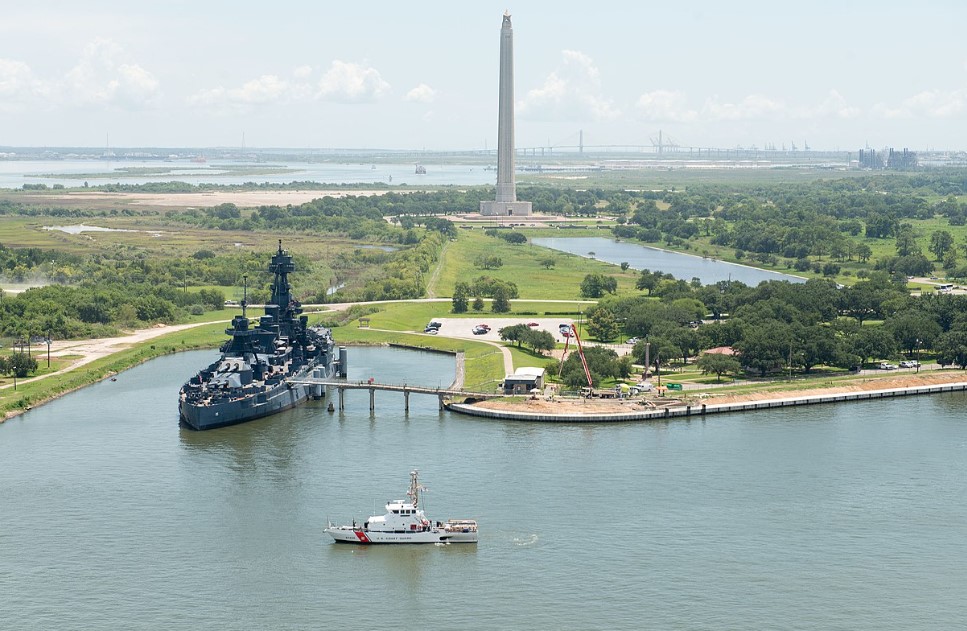
Houston Ship Channel: Industrial Maritime Photography Excellence
The sprawling Houston Ship Channel offers a stark contrast to the Energy Corridor's land-based industrial complexes. Following Buffalo Bayou's historic route to the Gulf of Mexico, this busy maritime thoroughfare creates dramatic aerial compositions where massive vessels navigate between petrochemical giants.
For photographers, the Fred Hartman Bridge infrastructure provides an iconic foreground element against the industrial skyline. Position your drone to capture ship wakes cutting through the water while ExxonMobil Baytown and other refineries vent steam in the background. The Shell Oil Company refinery at Deer Park stands as another striking industrial landmark visible in aerial photographs of the area.
The channel's visual drama isn't limited to industry—you'll find the towering San Jacinto Monument nearby, and can connect your visual story to the USS Texas battleship, now based in Galveston after years berthed at the battleground. Consider documenting the tension between commercial activity and coastal ecosystem impact, as environmental monitoring efforts create compelling narrative elements in your industrial maritime photography.
Port of Houston: Capturing Logistics in Action
Spanning over 50 miles of critical Gulf Coast waterway, Houston's bustling port complex offers aerial photographers an unparalleled canvas of maritime commerce in motion. From 400-foot elevations, you'll capture massive container ships docking alongside specialized terminals while cranes orchestrate the rhythmic loading and unloading process.
For compelling port operations oversight imagery, position your drone to showcase the relationship between the eight public terminals and adjacent petrochemical facilities. The most dynamic shots include oblique angles of Morgan's Point, where vessel traffic meets industrial infrastructure. The iconic Fred Hartman Bridge spanning the Houston Ship Channel provides a striking architectural element that contrasts beautifully with the industrial landscape below.
Container yard performance analysis benefits from vertical perspectives that reveal stacking patterns and transportation linkages. Your portfolio will highlight one of America's busiest Gulf Coast ports, where millions of tons of cargo flow through an intricate system of channels, docks, and rail connections essential to the national economy.
Spring Branch: Warehouse and Factory Panoramas
Located just northwest of Houston's inner loop, Spring Branch offers industrial photographers a dense concentration of manufacturing and logistics facilities ideal for extensive aerial documentation.
When you commission aerial shots here, you'll capture warehouse complexes with their distinctive loading docks and storage facility layouts that highlight operational efficiency.
Drones and helicopters provide perspectives that reveal factory rooftops with cooling towers and solar arrays, effectively showcasing production equipment that's impossible to capture from ground level. You'll often pay in the mid-hundreds of dollars for professional industrial shoots that deliver thorough visual assets for marketing or inspection purposes.
These images serve multiple stakeholders—from real estate brokers selling commercial properties to facility managers monitoring infrastructure conditions. Experienced aerial teams capture stunning marketing pictures that showcase industrial properties in their best light. With both fixed-wing aircraft and advanced DJI drones, you'll get clear visuals of Spring Branch's industrial ecosystem regardless of your specific documentation needs.
Houston Heights: Urban-Industrial Contrast Zones
Numerous photographers seek out Houston Heights for its compelling visual narrative where urban neighborhoods directly abut industrial zones. This area delivers striking aerial compositions featuring historic brick residences alongside metal warehouses and repurposed factories with exposed steel beams.
You'll capture the perfect juxtaposition of residential life meeting industrial functionality, with flat warehouse rooftops and weathered textures creating visual depth. The neighborhood's adaptive reuse potential is evident in former industrial buildings now housing commercial spaces, complete with original industrial facades and large windows.
From above, you'll document community integration challenges where narrow residential streets meet industrial yards. The area's proximity to rail lines adds dynamic elements to your shots, while the layered building heights create rich visual storytelling opportunities in a single frame. Professional photographers typically require a three-hour minimum for such on-location industrial photography projects due to setup complexity and environmental considerations.
Drone Technology Revolutionizing Houston's Industrial Documentation
While Houston Heights showcases the visual drama of industrial-residential boundaries, the tools photographers use to capture these scenes have undergone a remarkable evolution. You're witnessing drone technology transform pipeline infrastructure documentation with unprecedented efficiency and safety.
Advanced sensors now enable:
- Thermal imaging of energy infrastructure without requiring personnel to enter hazardous zones
- LiDAR-enhanced 3D modeling of industrial assets with greater detail and precision
- Exhaustive documentation of pipeline infrastructure through confined-space capabilities
- Integration with GIS platforms for streamlined engineering workflows
Despite Houston's complex airspace restrictions requiring FAA coordination, the commercial drone market continues its explosive growth. Aerial photography provides a unique bird's-eye view of overall site conditions, construction details, and infrastructure that ground-level photography simply cannot match.
With the global commercial drone market projected to expand by about $44.85 billion between 2022 and 2027, these technologies aren't just documenting Houston's industrial landscape—they're revolutionizing how you monitor, maintain, and visualize critical infrastructure.
Safety Protocols for Aerial Photography in Hazardous Environments
Safety remains paramount when capturing Houston's industrial landscapes from above, particularly as photographers navigate complex hazardous environments. Before flight, you'll need thorough risk assessments covering wind patterns, gas emissions, and electromagnetic interference specific to Houston's industrial zones.
All drone operators must hold FAA Part 107 certification and complete site-specific operator training protocols focused on the unique challenges of petrochemical facilities. You'll need appropriate PPE—hard hats, high-visibility clothing, and sometimes respiratory protection—while following strict incident response planning procedures for emergencies.
Select equipment with specialized sensors like thermal imaging and gas detection capabilities for Houston's complex industrial settings. Thermal imaging technology enables photographers to identify potentially dangerous heat anomalies in industrial equipment before they lead to failures.
Remember to coordinate with safety teams early in your planning process and use FAA-approved apps to identify restricted airspace throughout the Houston Ship Channel and surrounding industrial corridors.
GIS-Powered Location Intelligence in Industrial Photography
Beyond capturing stunning aerial views, today's industrial photography in Houston has transformed into a data-rich endeavor through GIS integration. You'll find these technologies revolutionizing asset management workflows by creating detailed spatial contexts for decision-making.
When you leverage location intelligence with aerial photography, you can:
- Analyze spatial relationships between industrial assets, revealing optimization opportunities invisible from ground level
- Improve facility maintenance planning through AI-powered predictive analytics that identify potential issues before they occur
- Visualize complex industrial sites in 3D models that integrate real-time data for dynamic monitoring
- Combine demographic, environmental, and infrastructure datasets to make strategic decisions about site selection and expansion
This synergy between high-resolution imagery and geospatial analysis delivers actionable insights that drive operational efficiency across Houston's industrial landscape. Historical aerial photography collections provide temporal change analysis that helps industrial facilities understand site evolution and plan future development more effectively.
Strategic Scheduling for Optimal Industrial Aerial Shots
Since timing directly impacts image quality, strategic scheduling represents perhaps the most critical factor in successful industrial aerial photography across Houston. You'll achieve the best results when the sun sits about 20 degrees above the horizon—typically during early morning or a few hours before sunset. This position minimizes shadows that might conceal important industrial features.
Consider seasonal timing considerations specific to Houston's latitude when planning your shoots. Use solar position tools like suncalc.org to pinpoint ideal illumination periods and avoid harsh midday sun that flattens industrial textures. For aerial photography from higher elevations, it's advisable to wait until the sun is slightly lower than 20 degrees.
Weather impact analysis is essential in Houston's climate, where humidity and variable cloud cover can considerably affect visibility. Prioritize days with clear or partly cloudy skies, adjusting your flight schedule seasonally to account for changing daylight patterns throughout the year.
Fortune 500 Headquarters: Architectural and Industrial Photography Opportunities
Houston's position as one of the top U.S. cities for Fortune 500 headquarters creates exceptional aerial photography opportunities you won't find elsewhere. With more than two dozen major corporate giants headquartered across the metro area, many clustered downtown, you'll capture striking contrasts between sleek glass towers and sprawling industrial complexes.
Energy titans like ExxonMobil, Shell, and the recently relocated Chevron showcase distinctive corporate office layouts that blend industrial functionality with sustainability-focused architecture. Houston ranks just behind New York and Chicago in the number of Fortune 500 headquarters, offering photographers access to an impressive array of corporate campuses.
Downtown's cluster of Fortune 500 headquarters alone represents hundreds of billions of dollars in annual revenue—and compelling visual stories.
For standout aerial industrial photography:
- Target dawn/dusk for dramatic lighting on downtown's glass headquarters
- Capture ExxonMobil's massive Spring campus with its integrated green spaces
- Frame energy processing facilities against Houston's skyline for scale contrast
- Seek aerial perspectives of Hewlett Packard Enterprise's tech-forward architecture