Where to Fly a Drone in Texas: Legal Locations with the Best Views
Texas offers a wide range of scenic and legal drone flying locations, from lakes and state parks to designated model aircraft fields and open public spaces. Locations like San Angelo State Park, Lake Whitney State Park, and Martin Dies Jr. State Park allow drone use in designated areas, while places like George Bush Park in Houston and Lake Houston provide open environments for recreational flying. Always check FAA airspace restrictions using B4UFLY or LAANC before launching, and confirm local park rules, as many scenic areas require permits or have designated zones. State Parks Where You Can Fly Drones in Texas
View this post on Instagram
Texas state parks offer some of the most visually striking landscapes for aerial photography, but drone use is regulated. Parks such as San Angelo State Park, Lake Whitney State Park, and Martin Dies Jr. State Park allow drone flights only in designated areas identified by park management. These zones are typically located away from campsites, wildlife habitats, and high-traffic visitor areas. Most Texas State Parks follow a policy that restricts drone use outside these areas unless you obtain a filming or special-use permit. Recreational flyers should always check with park staff upon arrival to confirm current rules. If you plan to film wildlife or conduct commercial operations, additional permissions may be required. Regardless of location, all drone flights must follow FAA regulations, including altitude limits and maintaining visual line of sight. Houston’s Best Drone Flying Spots Houston provides a mix of urban, coastal, and open park environments suitable for drone flying when done responsibly. George Bush Park (Houston): The Dick Scobee Model Airplane Field is a well-known designated flying area for RC aircraft and drones. Some areas may require membership with a local club, so check access rules before visiting. Lake Houston: This large reservoir offers wide-open water views and low obstacles, making it suitable for aerial photography. Be mindful of nearby controlled airspace and avoid flying over people or boats. Galveston Beaches (e.g., West End / Terramar Beach): These areas provide coastal scenery with fewer obstructions, though you must remain aware of nearby airport airspace and follow FAA guidelines. Always avoid flying over crowds, private property without permission, or restricted zones. Other Texas Cities With Legal Drone Launch Areas Some Texas cities have introduced designated areas or policies for drone operations, particularly for recreational flying. Plano: Plano has designated areas in certain parks where drone flying is permitted under city guidelines. Always confirm current park-specific rules. North Richland Hills: The city supports drone operations in select open spaces and has been involved in pilot programs for drone services. Recreational flyers should stick to approved areas. Frisco and Garland: While these cities have seen growth in drone-related services, recreational drone users must still follow standard FAA rules and local park regulations. In all cases, local ordinances govern where drones can take off and land, even though the FAA controls the airspace. Scenic Locations That Require Permits Some of Texas’s most scenic locations come with additional restrictions. LCRA Parks (Central Texas): Areas like Pedernales River access points and lakeside parks may require permits for commercial drone use. Contact the Lower Colorado River Authority for details. Texas State Parks: Outside designated zones, drone use typically requires a permit or special authorization. National Parks (e.g., Big Bend National Park): Drone use is completely prohibited for recreational purposes under National Park Service rules. Before flying in any scenic or protected area, verify rules with the managing authority to avoid fines or confiscation. Check Texas Airspace Restrictions Before You Fly Before every flight, check your location using B4UFLY or a LAANC-enabled app.
- Class G airspace: Generally allowed for recreational use under 400 feet
- Controlled airspace (Class B, C, D): Requires authorization
- Temporary Flight Restrictions (TFRs): May apply during events or emergencies
All drones weighing 0.55 lbs (250g) or more must be registered with the FAA, and commercial operators must hold a Part 107 certification. Best Drone Shots in Texas: Sunrise vs. Sunset by Location
View this post on Instagram
Timing your flight makes a major difference in the quality of your aerial footage. Texas landscapes shift dramatically between early morning and golden hour. Sunrise (Best for calm conditions and soft light):
- Hill Country (e.g., Pedernales River, Lake Travis): Morning fog and low-angle light create layered, cinematic depth across rolling hills.
- Lake Whitney & Lake Houston: Smooth water reflections are more likely before wind picks up.
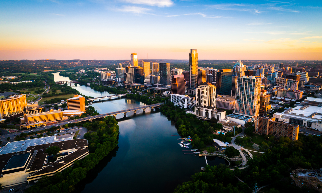
- Urban skylines (Austin, Dallas): Cleaner air and softer shadows highlight building detail.
Sunset (Best for dramatic color and contrast):
- San Angelo State Park: Warm tones enhance rugged terrain and open skies.
- Galveston Coast: Sunsets over the Gulf create strong silhouettes and vibrant color gradients.
- Downtown skylines: Golden hour reflections on glass buildings produce high-impact visuals.
Tip: Wind speeds are usually lower at sunrise, while sunset offers more dramatic lighting—choose based on your priority: stability or color. Where Drones Can’t Fly: Airports, Military Bases, and Restricted Areas Certain areas in Texas are strictly off-limits for drone flights. Avoid flying near:
- Airports without authorization
- Military installations such as Fort Bliss or NAS Corpus Christi
- Critical infrastructure and government facilities
- Large public events or crowded areas
These restrictions exist for safety and national security. Violations can result in fines or legal penalties. Get Airport Clearance Using LAANC in Texas The LAANC system (Low Altitude Authorization and Notification Capability) allows drone pilots to request airspace authorization quickly. Using apps like Aloft (formerly Kittyhawk) or AirMap, you can:
- Submit flight details (location, altitude, time)
- Receive near-instant approval in many controlled zones
- Adjust plans based on airspace limitations
If your request exceeds approved limits, manual authorization may take longer. Always confirm approval before flying. Safety Tips for Flying Drones in Texas Conditions Texas weather can be unpredictable and demanding on drone equipment. Heat Considerations:
- High temperatures can overheat batteries and motors
- Avoid flying during peak afternoon heat when possible
- Store batteries in shaded or insulated cases
Wind Awareness:
- Open areas like lakes and coastal regions experience strong gusts
- Check wind speeds before takeoff (under 15–20 mph is ideal for most drones)
- Be cautious when flying at higher altitudes where wind is stronger
Battery Performance:
- Heat can reduce battery efficiency and lifespan
- Plan shorter flights and monitor battery levels closely
- Land with at least 20–30% battery remaining for safety
Terrain Safety:
- Watch for trees, cliffs, power lines, and water hazards
- Maintain line of sight at all times
- Avoid crowded areas and respect privacy