Austin’s Aerial Views Every Visitor Should Catch
Austin offers a variety of elevated viewpoints, skyline perspectives, and scenic overlooks that showcase the city’s mix of urban growth and natural beauty. From hilltop views above the Colorado River to waterfront trails and iconic bridges, these spots give visitors a different perspective on the city’s landscape.
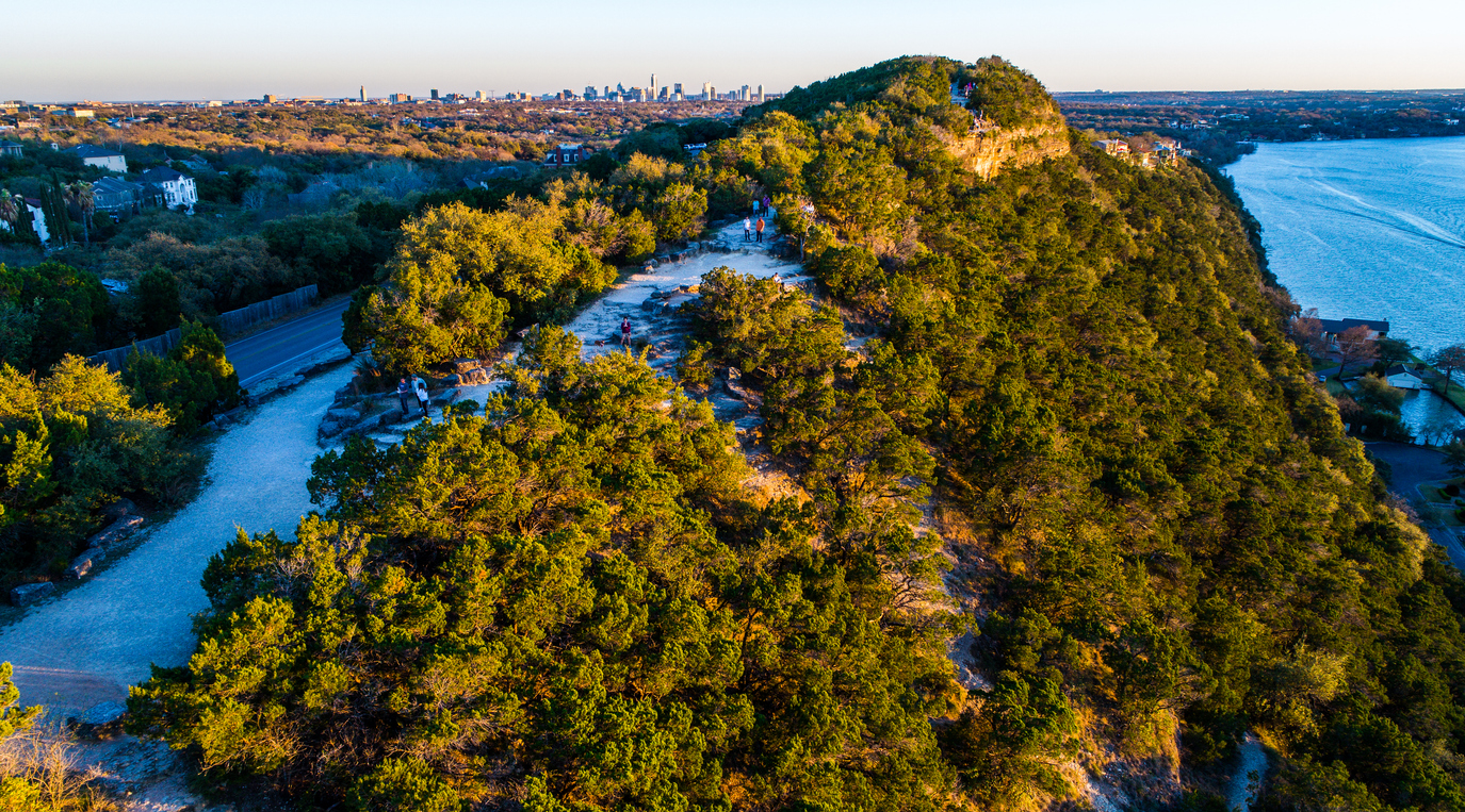
Mount Bonnell: Austin’s Classic Hilltop Viewpoint
View this post on Instagram
Mount Bonnell is one of Austin’s most well-known scenic overlooks, rising about 775 feet above sea level along Lake Austin. A short climb of approximately 100 stone steps leads to a viewpoint with sweeping views of the Colorado River, surrounding hills, and residential areas, with limited views of downtown in the distance. The site has been a popular destination since the 19th century and is recognized as a Recorded Texas Historic Landmark. It’s especially popular at sunset, though early morning visits offer fewer crowds and cooler temperatures.
Pennybacker Bridge Overlook for Iconic Austin Views
The Pennybacker Bridge Overlook, located along Loop 360, is one of Austin’s most photographed spots. From this vantage point, you’ll see the bridge’s distinctive steel arch spanning Lake Austin, surrounded by rolling Hill Country terrain. While often described as a panoramic viewpoint, the overlook primarily faces the river and hills rather than offering full 360-degree city views. A short but rocky hike leads to the overlook, so sturdy shoes are recommended. Limited roadside parking is available nearby, and the area can get crowded during peak hours.
Lady Bird Lake Boardwalk Skyline Views Along the Water
The Boardwalk at Lady Bird Lake stretches about 1.3 miles along the south shore, offering continuous waterfront views of Austin’s skyline. While not elevated like a hilltop, the boardwalk provides a clear, unobstructed perspective of downtown from the water’s edge. It connects seamlessly to the larger Ann and Roy Butler Hike-and-Bike Trail, making it easy to explore on foot or by bike. Features include:
- Wide walking paths with skyline sightlines
- Public art installations along the route
- Lighting for evening walks
This is one of the best places to capture reflections of the skyline at sunset or dusk.
Texas State Capitol Views of Downtown Austin
View this post on Instagram
The Texas State Capitol offers a different kind of visual perspective, with its historic dome set against Austin’s modern skyline. From the Capitol grounds, you can capture contrasting views of historic architecture and nearby high-rise buildings, especially along Congress Avenue, which creates a direct visual corridor through downtown. The Capitol itself is free to visit, and the surrounding grounds provide open space for photography throughout the day.
Zilker Park’s Wide-Angle Austin Skyline Views
View this post on Instagram
Zilker Park, located just south of downtown, offers some of the best wide-angle views of Austin’s skyline. Spanning more than 350 acres, the park provides open sightlines toward downtown, particularly from areas near Auditorium Shores and Lou Neff Point. Visitors can also enjoy:
- Walking and biking along the nearby trail
- Kayaking or paddleboarding on Lady Bird Lake
- Relaxing in open green spaces with skyline backdrops
Golden hour and early morning are ideal times for photography, when lighting is softer and crowds are lighter.
Riverside Drive: A Scenic Route for Skyline Views
Riverside Drive runs along the south side of Lady Bird Lake and offers multiple vantage points of the downtown skyline. While there are limited designated stopping areas, sections near Auditorium Shores and the South Congress Bridge area provide opportunities to pause and take photos safely. This route is best experienced during early morning or evening, when lighting enhances reflections on the water and traffic is lighter.
Drone Photography in Austin: What to Know
Drone photography in Austin is regulated by FAA rules and local restrictions, especially near downtown. Key considerations include:
- Controlled airspace near Austin-Bergstrom International Airport
- Restrictions around large gatherings and events
- FAA registration required for drones over 0.55 pounds
- Additional certification required for commercial use
Because much of downtown falls within regulated airspace, many visitors choose ground-based viewpoints instead.
Austin Skyline at Night: 6th Street and Rainey Street
At night, Austin’s skyline shifts into a mix of city lights, entertainment districts, and illuminated buildings. 6th Street is known for its vibrant nightlife, while Rainey Street features a mix of restored homes, bars, and new high-rise developments. From nearby viewpoints, you can capture the contrast between historic structures and modern buildings, especially with the skyline lit up after dark.
Congress Avenue Bridge and the Bat Viewing Experience
The Congress Avenue Bridge is famous for its colony of Mexican free-tailed bats, one of the largest urban bat colonies in the world. From spring through early fall, bats emerge at sunset in large groups, creating a unique visual experience above the water. Visitors typically watch from:
- The bridge itself
- Auditorium Shores
- Boat or kayak tours on Lady Bird Lake
This daily event has become one of Austin’s most recognizable attractions.
Best Times for Austin Skyline Photography
Timing plays a key role in capturing Austin’s best views.
- Golden hour (sunrise and sunset) provides warm lighting and strong reflections
- Early morning offers fewer crowds and clearer conditions
- Evening and dusk highlight city lights and skyline contrast
Weather conditions, lighting, and crowd levels can all affect the experience, so planning ahead helps make the most of each location.