Drone Photography Hotspots in the DFW Metroplex
You'll find some of the most visually rewarding drone photography locations across the Dallas–Fort Worth Metroplex, from expansive lakes to historic parks and designated flying fields. Popular spots like White Rock Lake and Lewisville Lake offer wide-open landscapes, while areas such as Lake Cliff Park provide striking architectural and skyline compositions. Before flying, always check FAA airspace restrictions using B4UFLY or LAANC, verify Temporary Flight Restrictions (TFRs), and follow local rules that govern where drones can take off and land.
Class B vs Class G: Understanding DFW Drone Airspace
Before launching your drone anywhere in DFW, it’s essential to understand how controlled and uncontrolled airspace affects your flight. Class B airspace surrounds major airports like Dallas/Fort Worth International Airport (DFW) and Dallas Love Field, extending in layered sections upward to 10,000 feet MSL. Flying in these areas requires authorization through LAANC or FAA DroneZone, even for recreational pilots. Class G airspace, by contrast, is uncontrolled airspace, typically found away from airports and urban cores. Recreational flyers can operate here without prior authorization, but must still follow FAA rules such as staying below 400 feet AGL, maintaining visual line of sight, and avoiding people or restricted areas. Understanding where these zones overlap is critical in DFW, where urban density and airport proximity create complex airspace boundaries.
Lake Cliff Park: Downtown Dallas with Historic Charm
View this post on Instagram
Located in Oak Cliff, just minutes from downtown Dallas, Lake Cliff Park offers one of the most visually unique drone perspectives in the metroplex. The park features a sunken lake, historic stone architecture, and skyline views that create strong geometric compositions. You’ll find restored features like the stone pergola and formal gardens, which work especially well for overhead and angled shots. The elevation changes across the park allow for layered compositions combining greenery, water, and city backdrops. Originally developed in the early 1900s as part of an amusement park, the site was later acquired by the City of Dallas and transformed into a public park—adding both historical context and visual depth to your footage.
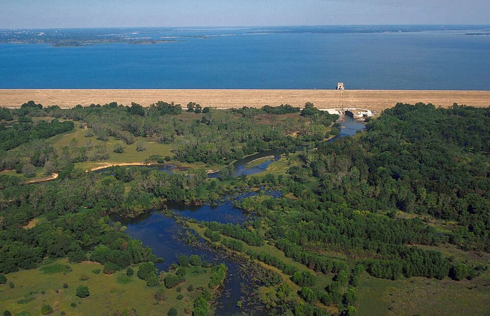
White Rock Lake: DFW’s Premier Recreational Drone Spot

Lewisville Lake: Wide-Open Water and Landscape Views
View this post on Instagram
Located in Denton County, Lewisville Lake covers nearly 30,000 acres, making it one of the largest lakes in North Texas. The surrounding parks and shoreline areas provide diverse aerial scenes, including marinas, wooded areas, and open water. Some areas near the lake fall within or near controlled airspace corridors, so it’s important to check authorization requirements before flying. Parks like Stewart Creek Park and surrounding public access points can offer strong visual compositions when operated within legal guidelines. This location is especially popular for sunrise flights, boating scenes, and seasonal shoreline changes.
Greater Southwest Aero Modelers: Practice and Community Flying
For a controlled flying environment, Greater Southwest Aero Modelers (GSWAM) in Fort Worth provides a dedicated flying field for RC and drone enthusiasts. It is a FAA-recognized FRIA (FAA-Recognized Identification Area), which allows certain aircraft to operate without Remote ID requirements within the designated area. Pilots typically need Academy of Model Aeronautics (AMA) membership and club access to fly. The site offers a structured environment for practicing aerial photography, testing equipment, and capturing dynamic shots of RC aircraft in motion.
Getting FAA Authorization for Class B Restricted Zones
Flying near DFW’s major airports requires proper authorization. The LAANC system allows near-instant approval for flights within approved altitude grids, while more complex requests may require submission through FAA DroneZone. Always:
- Check UAS Facility Maps for altitude limits
- Confirm no active TFRs (such as stadium events or VIP travel)
- Recheck authorization before each flight
Even with approval, pilots must follow all operational rules and remain aware of surrounding air traffic.
Privacy Laws and No-Fly Zones in Dallas-Fort Worth
Drone operators in Texas must follow both federal and state laws. Texas law restricts drone use over certain critical infrastructure, including power plants, refineries, and water facilities, without permission. Additional considerations:
- City parks may prohibit takeoff and landing
- Private property owners can restrict drone use
- Large events and stadiums trigger temporary flight restrictions
- Certain locations like military bases and airports are strictly off-limits
Always verify rules at the local, state, and federal level before flying.
Weather Conditions That Ground Drone Flights in North Texas
North Texas weather can change quickly, making flight planning essential. Strong winds, thunderstorms, and extreme heat can all affect drone performance and safety. Key considerations:
- Spring storms bring sudden gusts and lightning
- Summer heat can overheat batteries and reduce performance
- Cold weather can shorten battery life significantly
- Rain and low visibility make flying unsafe and illegal
Checking forecasts and wind speeds before each flight is critical.
Best Times for Aerial Photography in DFW
Lighting plays a major role in capturing high-quality drone footage across the metroplex.
- Golden Hour (sunrise and sunset): Soft, warm light ideal for landscapes and architecture
- Blue Hour (just after sunset): Strong contrast between city lights and sky tones
- Morning: Calmer winds and clearer air conditions
- Midday: Useful for sharp, high-contrast urban shots
Planning flights around lighting conditions will significantly improve your results.
Flying Safely in Texas Heat, Wind, and Changing Weather
North Texas weather can be unpredictable, especially in warmer months.
- Heat: High temperatures can overheat batteries and reduce flight time—fly early morning or late evening
- Wind: Open lakes often experience stronger gusts; monitor wind speeds above 10–15 mph carefully
- Thermals: Rising heat from pavement can destabilize drones in urban areas
- Battery care: Store batteries in shaded, cool areas between flights
- Storm awareness: Avoid flying before or after thunderstorms due to sudden wind shifts
Adapting to these conditions helps prevent equipment damage and unsafe flights.
Best Drone Shots by Time: Sunrise vs Sunset Locations
Different DFW locations shine at different times of day depending on light direction, activity, and atmosphere. Best at Sunrise:
- White Rock Lake (surrounding areas where permitted) – calm water and soft reflections
- Lewisville Lake – misty shoreline and minimal boat traffic
- Trinity Trails (Fort Worth) – golden light along the river
Best at Sunset:
- Lake Cliff Park – skyline glow and long shadows
- Grapevine Lake – warm tones across open water
- Downtown Dallas viewpoints (authorized areas) – illuminated skyline during blue hour
Blue Hour (After Sunset):
- Downtown Dallas skyline (from legal launch zones)
- Fort Worth Sundance Square (check restrictions)
Matching location to lighting conditions helps you capture clean reflections, balanced exposure, and dramatic color contrast.