Outdoor Drone Routes for Capturing Texas Nature
Texas offers diverse drone photography locations, from Big Bend’s Chihuahuan Desert landscapes to Palo Duro Canyon’s towering mesas and the bluebonnet-covered Willow City Loop. You’ll need to secure permits before flying in most state parks, while national parks prohibit drones entirely.
Focus on national forests, certain state park zones with approval, and private property where you’ve obtained permission. Proper ND filters and camera settings help manage Texas’s harsh sunlight, and understanding altitude limits and no-fly zones ensures you capture stunning footage legally across the state’s varied terrain.
West Texas Desert Routes: Big Bend and Guadalupe Mountains
While West Texas’s dramatic desert landscapes at Big Bend and Guadalupe Mountains National Parks may seem perfect for aerial photography, you’ll need to keep your drone grounded within park boundaries. The National Park Service prohibits launching, landing, or operating drones in all national parks under federal policy, with potential fines and penalties for violations.
However, you’re not completely out of options for West Texas aerial photography. Look for adjacent public lands such as Bureau of Land Management areas (where applicable), national forests outside Texas, or private ranch land where permission is granted. In the Big Bend region, many guided tour operators and ranches offer scenic access where drone use may be allowed with approval.
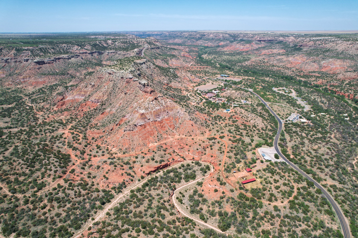
Texas Panhandle Canyons: Palo Duro and Caprock Escarpments
Palo Duro Canyon State Park offers some of Texas’s most dramatic aerial photography opportunities, but drone use is restricted and requires prior authorization from Texas Parks & Wildlife Department. Recreational drone flights are generally not allowed without a permit.
If you obtain permission or shoot from outside park boundaries, target Lighthouse Rock, Capitol Peak, and the canyon rim overlooks for layered geological formations. The canyon drops roughly 800 feet in some areas, making it one of the largest in the United States.
Caprock Canyons State Park presents another option, with fewer crowds and sweeping escarpments. Always verify current park rules before flying, as regulations can change.
Hill Country Waterways: Pedernales Falls and Canyon Lake
Drone use at Pedernales Falls State Park is generally prohibited without a filming permit, so plan accordingly. Instead, consider nearby public access points along the Pedernales River or private land with permission.
Canyon Lake and surrounding Hill Country areas provide more flexibility when flying from non-restricted public land or private property. Capture the limestone riverbeds, turquoise water, and rolling hills that define Central Texas landscapes.
Popular vantage points include overlooks near Canyon Lake and open ranchland areas where flight visibility and safety are easier to maintain.
Central Texas Bluebonnet Fields and Wildflower Seasons
Llano County and the Willow City Loop remain among the most popular areas for bluebonnet photography, but drone use must be handled carefully. Many roadside areas are narrow, privately owned, or heavily trafficked, making safe and legal launch points essential.
Peak wildflower season typically runs from late March through mid-April, depending on rainfall. In addition to bluebonnets, you’ll find Indian paintbrush, coreopsis, and phlox creating colorful aerial compositions.
Always avoid trampling flowers or disturbing traffic when scouting drone locations, and prioritize wide-open rural areas with clear landowner permission.
East Texas Piney Woods and Lake Country Drone Routes
The Piney Woods region offers a completely different aerial experience, with dense forests, winding lakes, and slower-paced rural landscapes. Areas near Sam Houston National Forest (outside restricted zones) and Lake Livingston provide strong opportunities for capturing tree canopy patterns and water reflections.
Big Thicket National Preserve does not allow drone use, so focus instead on surrounding public or private land where regulations permit. Lake areas such as Lake O’ the Pines and Wright Patman Lake offer open shorelines that make launching easier.
Gulf Coast Wetlands: Brazoria and Galveston Region
Texas’s Gulf Coast wetlands provide striking aerial visuals, from marshlands to barrier islands. However, many wildlife refuges—such as Brazoria National Wildlife Refuge—prohibit drones to protect sensitive habitats.
Instead, look for public beaches, coastal parks outside protected zones, and private waterfront properties where drone use is permitted. Galveston-area shorelines and less crowded sections of the coast allow you to capture tidal flats, sandbars, and coastal patterns.
Focus on early morning or late evening flights when winds are calmer and wildlife disturbance is minimized.
Texas Airspace Rules for State Parks and Public Lands
Before launching your drone anywhere in Texas, you must follow both FAA regulations and local land-use rules. Recreational pilots must register drones (if required), keep flights under 400 feet, and maintain visual line of sight at all times.
Key considerations include:
National parks and wildlife refuges: No drone use
State parks: Permit or special authorization required
Private property: Permission required
Cities and events: Temporary flight restrictions may apply
Always check FAA B4UFLY or LAANC systems before flying to confirm airspace conditions.
Legal Drone-Friendly Launch Sites in Texas
While many parks restrict drone use, several accessible and commonly used legal launch areas across Texas give you strong alternatives for aerial photography:
Lake Georgetown (U.S. Army Corps of Engineers land) – Open shoreline areas outside crowded recreation zones allow legal flights with standard FAA compliance
Sam Houston National Forest (designated areas) – Certain sections permit drone use if you avoid wildlife-sensitive zones and follow federal guidelines
Public beaches on the Gulf Coast (outside protected refuges) – Areas near Surfside Beach and parts of Padre Island National Seashore (outside restricted zones) offer wide, open launch space
Private ranch land in Hill Country and West Texas – Many landowners allow drone photography with permission, especially for sunrise/sunset shoots
Rural county roads and open land near Willow City Loop (with permission) – Ideal for bluebonnet season without violating roadside safety laws
Always confirm local restrictions, avoid crowds, and maintain visual line of sight and safe distance from people and wildlife.
Camera Settings and ND Filters for Harsh Texas Sunlight
Texas’s intense sunlight requires precise camera adjustments for quality footage. Manual control delivers better results than automatic settings.
Use these baseline settings:
Lock ISO at 100 for clean footage
Set shutter speed to double your frame rate (e.g., 1/60 for 30fps)
Use ND16–ND32 filters during midday
Adjust aperture between f/5.6 and f/11 depending on light
White balance settings between 6000–7500K help maintain natural tones, especially during sunrise and sunset.
Best Flight Times for Golden Hour Texas Light
Lighting conditions make a major difference in drone footage quality. Texas’s golden hour offers the best contrast, color, and shadow depth.
Morning flights begin shortly after sunrise, while evening golden hour starts about 30–45 minutes before sunset. Twilight periods can extend your shooting window, especially in wide-open landscapes.
Avoid midday flights when light is harsh and shadows flatten your footage. Instead, plan flights around early morning or late afternoon for the most visually striking results.